Famous dam in Karnataka
1.Krishna Raja Sagar dam in Mandya District


Krishna Raja Sagara, also popularly known as KRS, is a lake and the dam that creates it. They are close to the settlement of Krishna raja sagara in the Indian State of Karnataka. The gravity dam made of surki mortar is below the confluence of river Kaveri with its tributaries Hemavati and Lakshmana Tirtha, in the district of Mandya.
Krishna Raja Wadiyar IV Maharaj of Mysore constructed the dam during famine despite the critical financial condition in State. One of the architects of the dam was Chief Engineer of Mysore M. Visvesvaraya. There is an ornamental garden, Brindavan Gardens, attached to the dam.
The region of Mysore and especially Mandya had historically been dry and had witnessed mass migration to adjoining areas in the hot summers. A severe drought in 1875–76 had wiped out one-fifth of the population of the Kingdom of Mysore. Crop failures were common due to lack of water for irrigation.The Kaveri river was seen as a potential source of irrigation water for the farmers in and around Mysore in the erstwhile Kingdom of Mysore.
Construction began in November 1911, and 10,000 workers were employed. A mortar known as surki was used in place of cement, as the latter was not manufactured in India at the time and importing would prove costly for the state.By the time construction completed in 1931, around 5,000 to 10,000 persons had lost their homes to the project. However, they were rehabilitated and provided with agricultural land in the adjacent areas by the government.
Foundation Stone to dam was laid on 11 November 1911. The dam was built across the river Kaveri in 1924. It is the main source of water for the districts of Mysore. The water is used for irrigation in Mysore and Mandya, and it is the main source of drinking water for all of Mysore, Mandya and almost the whole of Bengaluru city, the capital of Karnataka. The water released from this dam flows into the state of Tamil Nadu and is stored in Mettur dam in the Salem district.
2. Nugu dam in mysore District


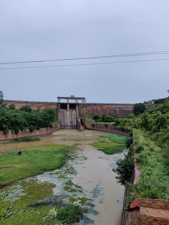
Nugu Dam is located in Beerwal village under Heggadadevana Kote or H. D. Kote taluk of Mysore district in Karnataka. The dam is constructed across the river Nugu flowing through the Kaveri basin. The reservoir was built to serve the purpose of irrigation and hydroelectricity generation. The construction of the dam was started in the year 1956-57 and was completed in the year 1959. The dam was built under the supervision of Sir M. Visveshwariah.
The reservoir has a length of 637.65 meters and a height of 43.58 meters above its deepest foundation. The total catchment area of the reservoir is 30.8 Th ha. The full reservoir level (FRL) of the structure stands at 753.4656 meters. The dam has 4 spillway gates of radial type.
Nugu Dam: A wonderful picnic spot
Nugu dam is situated in a picturesque location. The dam is surrounded by small hills on all sides. The area surrounding the reservoir is restricted for human activities except for the movement of the villagers living in the nearby spaces. But the back water catchment area is a wonderful spot for picnics. The catchment area extends to a hilly region that touches the border of Kerala. The place offers immense opportunities to bird photographers to capture various species of birds.
Tourist attractions near Nugu Dam
Nugu dam is situated in Mysore, one of the most famous districts of South India. Visitors can explore a number of tourist attractions while on a trip to the reservoir. Mysore and its surrounding areas are full of historic sites, natural attractions and archeological wonders. A few of the well-known tourist attractions of the region surrounding the dam are as follows:
3. kabini Dam in Mysore district


The Kabani dam is built on the River Kabini in the district of Mysore. The dam is 696 meters in length and was built in 1974. The exact location of the dam is near village Beechanahally, (Taluk) Heggadadevanakote. The catchment area of the dam is 2141.90 sq kms. It caters to the needs of around 22 villages and 14 Hamlets.
This dam also provides water to the combined system of Sagaredoddakere and Upper Nugu Dams. There is an arrangement of lifting and transfer of 28.00 TMC of water during the monsoons months from the Kabini dam to the other two smaller dams.
The dam is spread over an area of 55 hectares covering forests, rivers, lakes and valleys.
Kabini Dam An Exotic Tourist Destination
The Kabini dam becomes an exotic location for nature lovers, the beauty such that nature looks glamorous and enthralling. With over 250 species of birds alone, vibrancy is defined in unusual forms. You get a chance to see and explore, in a surrounding intricately knitted with forests, hills, all drawing picturesque scenery.
River ‘Kabini’, popularly known as ‘Kapila’, is one of the major rivers in Karnataka in India. It is formed as consequence of confluence of two rivers namely Panamaram River and Mananthavady River, originating in Wayanad District in Kerala state. It flows eastward to merge with another major River Cauvery at Tirumakudalu Narasipura near Mysore. You can have the best view of beautiful Kapila in Nanjangud, where there are 16 pillars mantap and 14 steps river bank. I have enjoyed the divine beauty of this holy river several times on my visit to the shrine of Lord Nanjundeswara alias Srikanteswara. Hereafter Cauvery amalgamates into Bay of Bengal, to lose her identity.
The important aspect is that Kabini Dam is an enjoyable Tourist Destination for nature lovers. The glamorous beauty of nature is enthralling. We can trace hundreds of species of birds. It is surrounded by elaborately connected forests, hills that present attractive picturesque scenery
4. Linganamakki dam in Shimoga District


The Linganamakki Dam (Kannada : ಲಿಂಗನಮಕ್ಕಿ ಜಲಾಶಯ) was constructed by the Karnataka State Government in 1964. Located in the Kargal village of Sagara taluk, the dam has a length of 2.74 kilometres (1.70 mi) stretching across the Sharavathi river. It is located about 9 km from Jog Falls
The Linganamakki dam was constructed by the Karnataka State Government in 1964. Located in the Sagara taluk, the dam has a length of 2.4 km, stretching across the Sharavathi river. It is located about 6 km from Jog Falls
The dam was designed to impound 4368 million cubic meter of water in an area of around 300 km, submerging 50.62 km of wetland and 7 km of dry land, with the remaining being forest land and wasteland. The dam's height is 1819 feet above sea level. It receives water mainly from rainfall and also from the Chakra and Savahaklu reservoirs, which are linked through Linganamakki through a canal. The water from the Linganamakki dam flows to Talakalale Balancing Reservoir through a trapezoidal canal with a discharge capacity of 175.56 cumecs. The length of this channel is about 4318.40 m with a submersion of 7.77 km. It has a catchment area of about 46.60 km. The gross capacity of the reservoir is 129.60 cu meters.
5. Harangi Dam In kodagu district


The Harangi originates in the Pushpagiri Hills of Western Ghats in Kodagu, Karnataka.Heavy rainfall from the south-west monsoon is the source of water in the catchment area of Harangi river which is about 717 km2.The length of the Harangi from its origin to the confluence with the Kaveri river is 50 km.The Harangi joins the Kaveri near Kudige in somwarpet taluk.
The Kaveri or Cauveri is one of the major rivers flowing through Karnataka. As it descends from the Deccan plateau and makes its way to the Arabian sea, it forms a number of tributaries. The river Harangi is one such tributary.
The river Harangi emerges from the Western Ghats in the Madikeri/Coorg district. It meanders till it reaches the Somwarpet Taluk. The total length of this river is estimated to be around 50kms.
Water levels in this river are highest after the monsoons. The river is a picturesque site and a popular destination for picnics. Many people also choose to hike through the hills around the river.
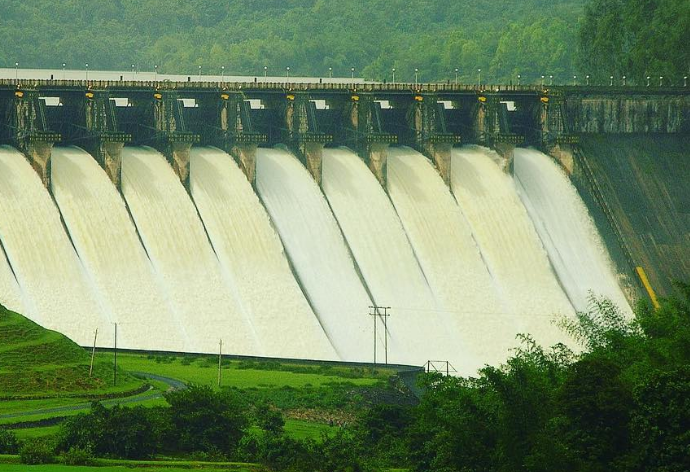
6.Tunga bhadra dam in ballari district


The Tungabhadra Dam also known as Pampa Sagar is constructed across the Tungabhadra River, a tributary of the Krishna River.The dam is in Hosapete, Vijayanagara district of Karnataka. It is a multipurpose dam serving irrigation, electricity generation, flood control, etc. This is a joint project of erstwhile Hyderabad state and erstwhile Madras Presidency when the construction was started;later it became a joint project of Karnataka and Andhra Pradesh after its completion in 1953. The main architect of the dam was Vepa Krishnamurthy, ISE, Engineer-in-Chief, Hyderabad State, after Police Action, an engineer from Madras PWD. There is a dispute between Andhra Pradesh Telangana and Karnataka for the water of Tungabhadra reservoir. He argued for the stability and longevity of the Dam, built of Surki Mortar viz a combination of mud and limestone. It's the only non-cement and concrete dam in the country and has withstood the test of time for over 70 years, and may well cross many more decades. He envisioned it as being built with a large contingent of manual labour, as best suited to Indian labour availability and employment. The main contractor for the dam was Venkat Reddy Mulamalla, from Konour village,Konour village, Mahabubnagar, Hyderabad.
The river Tungabhadra derives its name from two streams viz., the Tunga, about 147 km (91.6 miles) long and the Bhadra, about 178 km (110.9 miles) long which rise in the Western Ghats. The river after the influence of the two streams near Shimoga, runs for about 531 km (330 miles) till it joins the river Krishna at Sangamaleshwaram in Andhra Pradesh. It runs for 382 km (237 miles) in Karnataka, forms the boundary between Karnataka and Andhra Pradesh for 58 km (36 miles) and further runs for the next 91 km (57 miles) in Andhra Pradesh. The total catchment area of the river is 69,552 km2 (26,856 Sq miles) up to its confluence with Krishna and it is 28,177 km2 (10,880 Sq miles) up to Tungabhadra Dam. It is influenced chiefly by the South-West monsoon. It is a perennial river but the summer flows dwindle to as low as 2.83 to 1.42 cumec (100 to 50 cusec).
7. Bhadra Dam in chikmagaluru district


Bhadra dam is built on the river Bhadra, which is a tributary of the River Tungabhadra. It is situated in Chikmagalur town in Karnataka. Irrigation and irrigation storage are one of the best benefits that are enjoyed through this dam. It also provides power to towns andvillages nearby. It was commissioned in 1965.
Bhadra dam is a beautiful dam built across the river Bhadra, and hence the dam derives its name. This location crowns itself as Chikmagalur's key tourist attraction. Bhadra Dam is at a distance of 78 km from the mainland of Chikmagalur. ... There's a wildlife sanctuary here through which flows the Bhadra river.
The Bhadra Dam, which has created the Bhadra Reservoir, is located on the Bhadra River a tributary of Tungabhadra River. Bhadra dam is located in the border of Bhadravathi and Tarikere, in the western part of Karnataka in India. The benefits derived from the reservoir storage are irrigation with gross irrigation potential of 162,818 hectares (402,330 acres), hydro power generation of 39.2 MW (three powerhouses, located on the right and left bank main canalsdrinking water supply and industrial use. The dam commissioned in 1965 is a composite earth cum masonry structure of 59.13 metres (194.0 ft) height with length of 1,708 metres (5,604 ft) at the crest level, which submerges a land area of 11,250.88 hectares (27,801.5 acres).
8. Basava sagara Dam in yadgiri District


Basava Sagar Dam, previously known as Narayanpura Dam, is a dam constructed across the Krishna River at Yadgir District, Karnataka State, India.The reservoir that it impounds is known as Basava Sagar, and has a total storage capacity of 37.965 tmcft (1.075 km³), with 30.5 tmcft (0.85 km³) live storage. The full reservoir level is 492.25 m MSL and the minimum draw down level is 481.6 m MSL. It was a single purpose project meant only for irrigation, but downstream electrical generation and drinking water considerations enter into its management. The dam is 29 meters high and over 10.637 kilometres (6.610 mi) long and has 30 gates for water release. 22 Spillway Gates are present in the Dam It took Rs. 50.48 crore to complete.
Basava Sagar Dam is built across River Krishna and is also called Narayanpur Dam. It is located in Narayanpur in Yadgir district of Karnataka. Yadgir is a famous district with historical value that belongs to the Raichur constituency. This place is closer to Bijapur district.
Basava Sagar Dam was a single purpose project and was meant for irrigation but drinking water production and generation of downstream electricity are some of the functions of this dam. It took around 50 crores for the construction of this dam in 1982. This project has an estimated capacity of 31.47 TMC.
Basava Sagar Dam, also called Narayanpur Dam is built across River Krishna. It is located in Narayanpur in Yadgir district of Karnataka.
.
Basava Sagar Dam was a single purpose project and was meant for irrigation but drinking water production and generation of downstream electricity are some of the functions of this dam. It took around 50 crores for the construction of this dam in 1982
9. vani vilsaa sagara Dam in Chitradurga district


Vani Vilasa Sagara, popularly known as Mari Kanive (Kannada: ಮಾರಿ ಕಣಿವೆ) is a dam in Hiriyur Taluk, Chitradurga District, in the Indian state of Karnataka. It is located about 20 km south-westerly to Hiriyur, 32 km north-easterly to Hosadurga, 58 km south-easterly to Holalkere, 50 km northerly to Huliyar, 60 km southerly to Chitradurga, and 180 km north-westerly to Bangalore.
Vani Vilasa Sagara was built by the Mysore Maharajas pre-independence across the river Vedavathi. Vani Vilasa Sagara is the oldest dam in the state. The dam is an exquisite piece of architecture, an engineering marvel for that time. The dam irrigates a large area of the Deccan region of Central Karnataka, which is otherwise largely a dry land. It irrigates more than 100 km² of land in Hiriyur and Challakere taluks through right and left bank canals. Vani Vilasa Sagara dam is also the source of domestic water for water capacity is very high due to unusual rain dam become dry Hiriyur and Chitradurga
Vani Vilasa Sagara across the river Vedavathi was built by the Mysore Maharajas pre-independence. The project was initiated by the regent Queen Maharani Kempa Nanjammani Vani Vilasa Sannidhana who was a widow of Maharaja Chamaraaja Wadiyar. She is known for her exemplary social works. For the construction of this dam royals of Mysore had to pledge royal jewellery due to shortage of money, that is why it was named as "Vani Vilasa Sagara". The Mari Kanive irrigation project was initiated by Sir. Mark Cubbon, the British Resident of Mysore.Further improvements to the dam was initiated by Diwan Sheshadri Iyer in 1897at the order of his Highness the Maharaja of Mysore Sri Krishnaraja Wadiyar IV. Vani Vilasa Sagara is higher than KRS dam of Mysore.
10. Renuka Sagara Dam in belgaum district


Renuka Sagara, also known as Malaprabha reservoir and Navilutheertha reservoir, is a dam and impounding reservoir constructed across the Malaprabha River in the Krishna River basin. It is situated at Navilatirtha village in Savadatti Taluk Taluk of Belgaum district in North Karnataka, India. The dam is 43.13 metres high and has 4 vertical crest gates; it impounds a large reservoir with a gross surface area of 54.97 square kilometres, and storage capacity of 37.73 thousand million cubic feet. It is an earthen and masonry dam which caters to the Irrigation needs for over 540,000 acres, and hydroelectric power generation.
Renuka Sagar reservoir is created by impounding Malaprabha River with Navilatirtha Dam (Navil in Kannada means peacock)
Malaprabha Dam is the shortest dam in Karnataka built across Malaprabha river.The Malaprabha River (Kannadaಮಲಪ್ರಭ ನದಿ )is a tributary river of the Krishna River and flows through the state of Karnataka in India. It rises in the Western Ghats at an altitude of 792 m in the state's Belgaum district. The river joins Krishna River in Kudalsangam in Bagalkot district. Situated in a narrow gorge called 'Peacock gorge,' the length of the dam is about 155 m. This dam is designed mainly to meet the drinking water requirements of the people of Belgaum, Dharwad, Gadag, and Bagalkot. Malaprabha Dam is located 3 km from Saundatti Yellamma Temple. Saundattti in Belgaum District is 38 km from Dharwad, 58 km from Hubli and 112 km from Belgaum.
Article by .
Ashwini G k
ECE department.
GSSSIETW Mysore.

Thanks for letting know about these wonderful places👏
ReplyDeleteGood information 👍
ReplyDeleteSuper 👌
ReplyDeleteInformative👏
ReplyDeleteGood job 👍
ReplyDeleteGood one 👏
ReplyDeleteSuper 👌🙏
ReplyDelete👏👏
ReplyDeleteGood work 👍
ReplyDeleteNice info👍
ReplyDeleteGud info
ReplyDeleteGud
ReplyDeleteNice good information
ReplyDeleteInformative👏
ReplyDeleteGreat information.
ReplyDeleteUseful information
ReplyDeleteWonderful job
ReplyDelete👏👏
ReplyDeleteGood Tata
ReplyDeleteGood information..
Good information
ReplyDeleteGood job
ReplyDelete👏👏
ReplyDeleteVey informative 👏
ReplyDeleteGood 😊
ReplyDeleteNice dr
ReplyDeleteGood work 👏👏👏
ReplyDeleteGood work👏
ReplyDeleteGood work
ReplyDeleteNice work
ReplyDeleteSuper imfoinforma
ReplyDeleteSipSu ImforInform
ReplyDeleteGood work, beauty
ReplyDelete👏👏👏
ReplyDelete